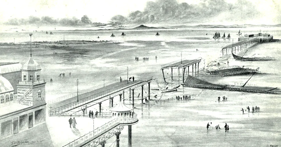
1903 Ulysses Storm among windiest ever in British Isles
A mighty storm that tore across Ireland and the UK more than a century ago produced some of the strongest winds the British Isles have ever witnessed.

Scientists reviewed Storm Ulysses of 1903 by digitising paper-based weather readings from the time and subjecting them to a modern reanalysis.
Many places would have felt gusts in excess of 45m/s (100mph or 87 knots).
The cyclone left a trail of death, shipwrecks, smashed infrastructure, uprooted trees and widespread flooding.
"We think it is likely that the winds were stronger in some locations than anything in the modern period 1950-2015," explained Prof Ed Hawkins from the University of Reading and the National Centre for Atmospheric Science.
"The precise values are a bit uncertain as the reanalysis does not produce gust values at the surface but they would have been pretty high to cause the damage we see in photos from the time - on a par with big storms in 1990, 1997, 1998 and the Great Storm of 1987," he told the BBC.
Storm Ulysses is so called because it inspired a passage in James Joyce's famous novel Ulysses.
O yes, J.J. O'Molloy said eagerly. Lady Dudley was walking home through the park to see all the trees that were blown down by that cyclone last year and thought she'd buy a view of Dublin.
The windstorm blasted through the British Isles over 26 and 27 February. Its track ran across Ireland, northern England and Scotland.
The Times newspaper recounted widespread damage, a sizeable number of injuries, and fatalities.
The Royal National Lifeboat Institution (RNLI) reported 10 significant crew rescues from distressed ships. A pier in Morecambe was damaged, and a train in Cumbria was blown over.
Ulysses' ferocity was well recognised at the time. But by reanalysing the raw weather observations from 1903, using the very latest modern numerical modelling techniques like those that produce today's daily forecasts, researchers have now obtained a new, more detailed appreciation of the event.
The study was made possible by an army of volunteers who converted the hand-written records from 1903 into a spreadsheet format that could be fed into a 21st century supercomputer.
The records - principally from the UK Met Office's "Daily Weather Reports" - included measurements of pressure, temperature, wind speed, sunshine and rainfall, and were taken at select sites across the British Isles and continental Europe.
Atmospheric pressure is the key parameter for a modern simulation of the event.
"By recovering these observations and building them into our modern methods for making reconstructions, we can draw a picture of the atmosphere and how it was behaving at the time," said Prof Hawkins. "And it looks very credible. It has winds simulated in the reconstruction that could have caused the damage that we see from the documentary evidence and the photographs."
A good example is the Leven River in Cumbria where the train toppled over as it crossed a viaduct. The simulation indicates there would have been winds above 40m/s (90mph or 78 knots) at that location on the morning of the 27th.
The weather can always produce freak conditions in specific places, but when the British Isles region is considered as a whole - the reanalysis puts Storm Ulysses in the top five strongest wind events.
Scientists say mining old meteorological data is a vital undertaking if we're to understand how our climate is changing.
It's only by having dense historic data that we can put modern weather extremes in their proper context and see the full range of possibilities for the future.
The difficulty is giving computers access to this information, some of which is centuries old.
There are thought to be billions of hand-written data points sitting in meteorological archives around the world waiting to be transcribed.
Volunteers working on "citizen science" platforms such as Zooniverse have made a dent in the problem but it will take an immense effort to recover the entire resource.
Co-worker from Reading, Dr Stephen Burt says: "There are always some caveats about highest gusts, the two main difficulties being, firstly, that the instruments are working at the very edge of their capability; and, secondly, of course, that most such records come from very exposed sites. How representative such records are is open to question.
"But caveats aside, the highest UK low-level gust for which there is at least a reasonable balance of probability is that of 118 knots (61m/s) at Kirkwall, Orkney, at 09:12 GMT on 7 February 1969." That's 136mph.
Prof Hawkins and colleagues report their reanalysis of Storm Ulysses in the journal Natural Hazards and Earth System Sciences.
The Reading researcher will also present the project this week to the European Geosciences Union General Assembly in Vienna, Austria. He'll also be speaking on this week's Science In Action programme on the BBC World Service.
-bbc


