Mappa Mundi: The greatest medieval map in the world
From a small island in the Venetian lagoon, a 15th-Century monk somehow designed an astonishingly accurate planisphere of the world.

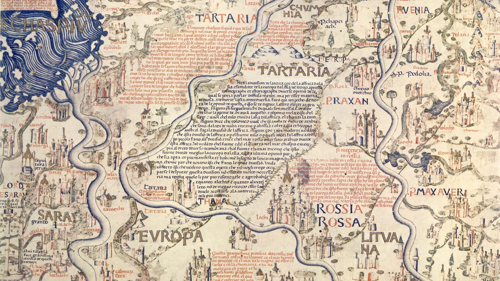
On the second floor of the Library of Saint Mark in Venice, a map of the world occupies an entire room – and rightfully so, considering its historical significance and imposing size (2.4m x 2.4m, bigger than a king size bed). Completed in 1459, the Mappa Mundi is the compendium of all the geographical knowledge of the time and is arguably the greatest medieval map of the world.
Almost twice as large as the famous English Hereford Mappa Mundi (ca 1300), this exquisitely decorated planisphere showcasing Europe, Africa and Asia was the masterpiece of Fra Mauro, a monk of the Camaldolese order who lived on the small Venetian island of San Michele.
Although the monk never set foot outside Venice, his Mappa Mundi is amazingly accurate in its depiction of cities, provinces, continents, rivers and mountains. America isn't on the map, since Christopher Columbus would take his trip across the ocean 33 years later; and nor is Australia. But Japan (or in Fra Mauro's words, "Cipango") is there, making its first appearance on a Western chart. Even more surprisingly, Africa is correctly drawn as circumnavigable, long before the Portuguese rounded the Cape of Good Hope in 1488.
"It's the oldest surviving medieval map," said Meredith Francesca Small, author of the book Here Begins the Dark Sea, also describing it as the most complete medieval map to survive into modernity. "It's the first map to be based on science more than religion. The Hereford map is all propaganda, religious propaganda."
While the Hereford map depicted Heaven and Hell and was designed to serve as a compendium of the world's knowledge from a spiritual perspective, Fra Mauro took a scientific approach to his cartography. He declared in his inscriptions that he would "verify the text by practical experience, investigating for many years and frequenting personas worthy of faith who have seen with their own eyes what I faithfully report here".
There's more than scientific and historical relevance to it, though. The most striking aspect of the map, which immediately catches your eye after ascending the white marble stairs of the Library of Saint Mark, where some of the world's most precious and ancient manuscripts are kept, is its sheer splendour.
"It's huge, beautiful, fantastically crafted," said historian Pieralvise Zorzi. Beyond the outlines of countries and continents, Fra Mauro's Mappa Mundi is a magnificent golden and blue painting composed of minute drawings of gorgeous palaces, bridges, sailing ships, rolling blue waves and outsized sea creatures, plus a total of 3,000 cartigli – red and blue annotations written in ancient Venetian that tell stories, anecdotes and legends.
In Norway, for instance, a cartiglio indicates the location where the Venetian merchant Pietro Querini came ashore after a shipwreck. As the tale goes, he not only survived the accident, but he brought stockfish back home, thus starting the Venetian passion for baccalà (the creamy fish spread you can find in every osteria).
Another cartiglioindicates Tharse, the "kingdom where the Magi came from", then thought to be located somewhere between China and Mongolia.
All these annotations are legible on the map, and are relatively easy to decipher for Venetian speakers since the current dialect is not dramatically different from the idiom of the 15th Century. However, the inscriptions are also translated into English on an interactive map created by the Galileo Institute and Museum in Florence. Displayed on a flat screen in the same exhibition space as the Mappa Mundi, it provides the somewhat peculiar experience of entering the mind of a savant monk and reading the world through his medieval eyes.
It was not a small world. Although Fra Mauro lived his entire life in his island monastery in the lagoon backwaters, he tapped into the knowledge of travellers and merchants who crossed paths in the flourishing trading city of Venice that was "the capital of cartography at the time", explained Saint Marks librarian Margherita Venturelli.
Maps were fundamental for trade because if you have a good map, you can go everywhere
"Maps were fundamental for trade because if you have a good map, you can go everywhere," added Zorzi. "Every innovation in terms of cartography was welcome in Venice, and well-paid."
Fra Mauro's main source for Asia was merchant and fellow Venetian Marco Polo, who had published his travel accounts more than 150 years earlier. On the map, 150 locations are directly traceable to Marco Polo's Travels; for instance, the Mount of Adam was placed in the island of Ceylon (today's Sri Lanka), where, according to legends recounted by Polo, the first man's body was believed to be buried, together with his teeth and even his bowl, which was supposed to have the magical property of multiplying food.
Besides Polo, Fra Mauro had numerous sources around the globe. The fact that the chart looks upside down to contemporary Western eyes, with the south on top, might indicate that he was inspired by Arab cartography, like a 12th-Century map by North African geographer Muhammad al-Idrisi. The numbers that Fra Mauro lists as "the Distance of Heavens" are from mathematician and astronomer Campanus de Novara. "From the centre of the world to the surface of the Earth there are 3,245 miles. From the centre of the world to the lower surface of the heavens of the Moon there are 107,936 miles," and so on, he writes in the top left corner of the Mappa Mundi.
Fra Mauro also displayed a healthy scepticism and wasn't shy of criticising – as well as sometimes using –the revered Ptolemy's Geography, a treaty written in Alexandria, Egypt, by Claudius Ptolemy in 150 CE and lost for centuries to the Western world until it was rediscovered and translated in Latin again in the 1400s.
This Renaissance rationalist attitude also showed in the way he placed Adam and Eve in the Garden of Eden outside of the planisphere, making it clear that Heaven is not a place on Earth; a statement that separated religion and geography and was forward thinking for any medieval man, let alone a monk.
These novelties, and the fact that the map was completed few decades before Christopher Columbus sailed to America, contribute to Fra Mauro's Mappa Mundi being considered the geographical link between the Middle Ages and the Renaissance. To contemporary visitors, his map is a reminder of the fact that maps were once not only practical tools, but also a matter of beauty – and a way to tell the most extraordinary stories.
-bbc


